Ilke homes updated consultation documents do not meet key material objections already raised. Further objections are made below.
Site Design, Flooding and Drainage
Whilst some tweaks have been made to the design of the development, previous material objections are still relevant and have not been addressed. (See Appendix A for flooding objections from a local resident). We understand that the attenuation pond now has a freeboard of 0.616m and that this has been doubled from the previous 0.3m and also that the POS (public Open Space) has been increased slightly with the crate system underneath. We note the POS is still well below the minimum requirements for the number of houses being commissioned on this site. Public Open Space – In accordance with the standards set out within Policy EN10, a scheme of 133 dwellings would be required to provided 1,850 sqm of amenity green space on site (excluding attenuation features). The Applicant has revised the scheme to increase the level of public open space on site from 750sqm to 1,417sqm. Not meeting even basic levels of public open space requirements.
There are further objections which include:
Appendix A – Objections of a local Resident
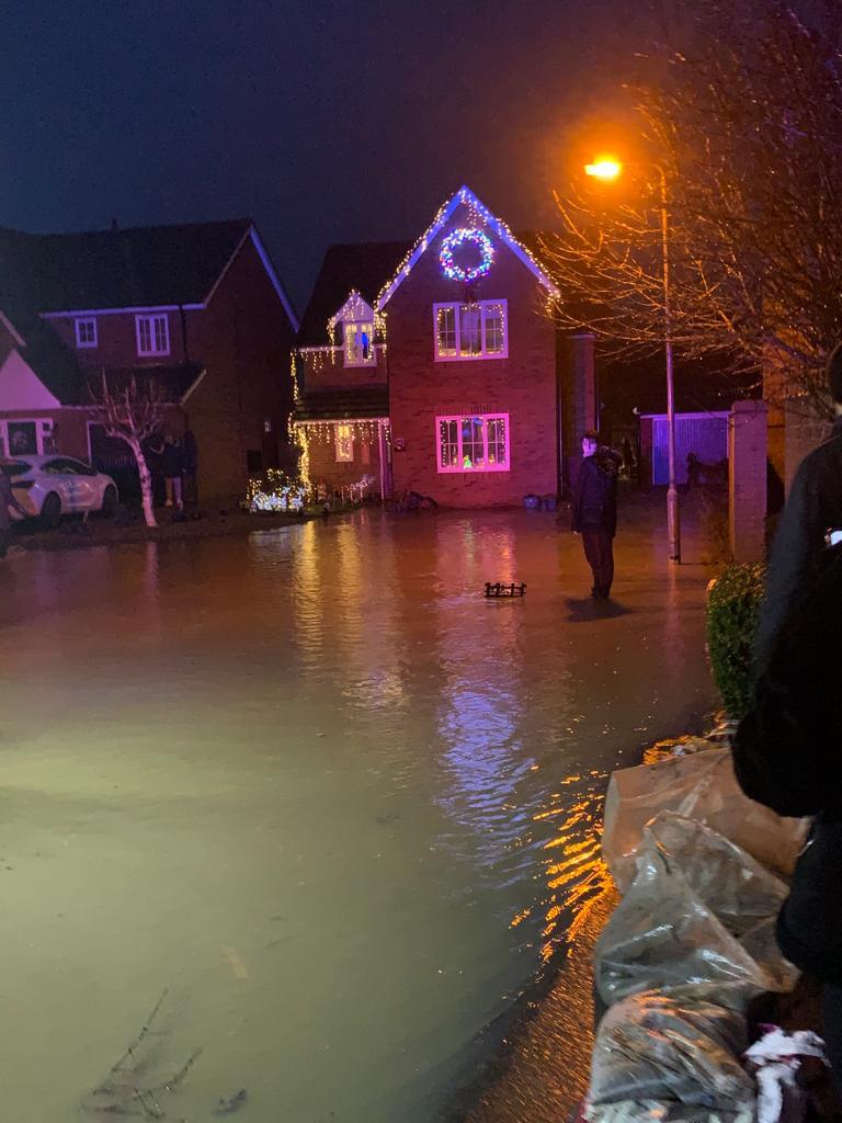
The development area is very likely to flood AGAIN. The proposed plans show the majority of the land being covered in tarmac, local standards and additional local guidance uncontrolled discharge volumes on developed sites can be up to TEN TIMES greater than pre-developed/greenfield equivalent.
Steep slopes increase runoff velocity, creating a challenge for Suds. However, check dams and storage features can be used to slow runoff rates and accommodate infiltration and/or attenuation. The site has mostly tarmac roads, non-permeable paving, large roof run off and no features to stop the flooding such as swales or filter strips with little gardens for absorption.
There is no discussion about the maintenance and costs of the balance pond\SUDS scheme. Because of the importance of ensuring that any SUDS installed in connection with a large-scale urban development are properly inspected and maintained over the life of the development, the District Council may, de-facto, find itself faced with this responsibility. This possibility should be anticipated in each case at the planning stage and, if applicable in that case, provision made at that stage for the funding of the future inspection and maintenance of the installation by the Council. Is this SUDs scheme being abandoned or maintenance take over by the council? I can’t find this in the documentation?
The development looks like it’s going to be considerably higher than my property. This just means the water will just run faster.
My other flood objections are:
So according to this said guidance document, the design should include, but instead does NOT seem to include:
Please see comments below made by The Flood and Water Management Team (Comment made 14/05/21)
Thank you for consulting us on the above planning application.
Having reviewed the applicant’s submitted documents located within; “Flood Risk Assessment and Drainage Strategy” ref 20241-RLL-20-XX-RP-C-001 rev P02 dated 9th March 2021, prepared by Rodgers Leask Ltd, we would advise that there is insufficient information available to comment on the acceptability of the proposed surface water drainage scheme for the proposed development.
Our information requirements in support of Full planning application are outlined in our document Local Standards and Guidance for Surface Water Drainage in Northamptonshire accessed via; https://www.floodtoolkit.com/wp-content/uploads/2017/09/Local-Standards-for-publication-v1.3- September-2017.pdf .
With reference to this document, we note that the submitted surface water drainage information fails on the following grounds:
1) The total site area is noted as 3.7ha with an impermeable area of 1.956ha. The discharge rate for the site should be proportional to the impermeable area not the whole site area.
2) We note the required 300mm freeboard for the attenuation basin. However, the FRA indicates it is proposed that the on-site surface water pipe network and attenuation basin would be offered for adoption with Anglian Water. The Water Authority DCG requires a freeboard of 600mm for basins considered for adoption.
3) Within 24hours of reaching top water level attenuation elements should be able to
accommodate 80% of the follow on 1 in 10 year storm.
Overcoming our concerns:
Our concerns can be overcome by submitting surface water drainage information which covers the deficiencies highlighted above.
We ask to be re-consulted on this requested surface water drainage information. We will provide you with bespoke comments within 21 days of receiving a formal re-consultation. We cannot support the application until adequate surface water drainage information has been submitted
Upon submission of revised surface water drainage information, we may deem that the impacts of surface water drainage have been adequately addressed, pending the imposition of any relevant planning conditions or we may consider that the nature of the proposal, drainage solution or information submitted remains insufficient to overcome our concerns.
Please note that our comments only cover the surface water drainage implications of the proposed development. If you are minded to approve the application contrary to any outstanding concerns, I would be grateful if you could notify us, to give us the opportunity to make further representations. In the event that the applicant appeals a refusal of their planning application or non-determination, we would be prepared to fully support Local Planning Authority and provide evidence at any public inquiry or informal hearing in relation to surface water drainage matters. In view of above, should you require any further information, or wish to discuss these matters further, please do not hesitate to contact us.
Please see comments made by Anglian Water Services Ltd (Comments made 12/05/21)
Section 1 – Assets Affected
There are assets owned by Anglian Water or those subject to an adoption agreement within or close to the development boundary that may affect the layout of the site. Anglian Water would ask that the following text be included within your Notice should permission be granted.
Anglian Water has assets close to or crossing this site or there are assets subject to an adoption agreement.
Therefore the site layout should take this into account and accommodate those assets within either prospectively adoptable highways or public open space. If this is not practicable then the sewers will need to be diverted at the developers cost under Section 185 of the Water Industry Act 1991. or, in the case of apparatus under an adoption agreement, liaise with the owners of the apparatus. It should be noted that the diversion works should normally be completed before development can commence.
WASTEWATER SERVICES
Section 2 – Wastewater Treatment
The foul drainage from this development is in the catchment of Broadholme water Recycling Centre that will have available capacity for these flows Section 3 – Used Water Network
This response has been based on the following submitted documents: Application Form, Location Plan, 20241-RLL-20-XX-DR-C-203-A-FLOOD ROUTING PLAN, 20241-RLL-20-XX-DR-C-202-A-GENERAL ARRANGEMENT.
The sewerage system at present has available capacity for these flows, via gravity connection. If the regime changes to pumped, we would wish to see a detailed design submitted to the Local Planning Authority so that we can reassess the impact on our network. If the developer wishes to connect to our sewerage network, they should serve notice under Section 106 of the Water Industry Act 1991. We will then advise them of the most suitable point of connection.
INFORMATIVE – Notification of intention to connect to the public sewer under S106 of the Water Industry Act Approval and consent will be required by Anglian Water, under the Water Industry Act 1991. Contact Development Services Team 0345 606 6087.
INFORMATIVE – Protection of existing assets – A public sewer is shown on record plans within the land identified for the proposed development. It appears that development proposals will affect existing public sewers. It is recommended that the applicant contacts Anglian Water Development Services Team for further advice on this matter. Building over existing public sewers will not be permitted (without agreement) from Anglian Water.
INFORMATIVE – Building near to a public sewer – No building will be permitted within the statutory easement width of 3 metres from the pipeline without agreement from Anglian Water. Please contact Development Services Team on 0345 606 6087.
INFORMATIVE: The developer should note that the site drainage details submitted have not been approved for the purposes of adoption. If the developer wishes to have the sewers included in a sewer adoption agreement with Anglian Water (under Sections 104 of the Water Industry Act 1991), they should contact our Development Services Team on 0345 606 6087 at the earliest opportunity. Sewers intended for adoption should be designed and constructed in accordance with Sewers for Adoption guide for developers, as supplemented by Anglian Water’s requirements. Section 4 – Surface Water Disposal The preferred method of surface water disposal would be to a sustainable drainage system (SuDS) with connection to sewer seen as the last option. Building Regulations (part H) on Drainage and Waste Disposal for England includes a surface water drainage hierarchy, with infiltration on site as the preferred disposal option, followed by discharge to watercourse and then connection to a sewer.
Anglian Water has reviewed the submitted documents Application Form, Location Plan, 20241-RLL-20-XX-DR-C-
203-A-FLOOD ROUTING PLAN, 20241-RLL-20-XX-DR-C-202-A-GENERAL ARRANGEMENT and can confirm that these are acceptable to us. We require these documents to be listed as approved plans/documents if permission is granted.
Section 5 – Suggested Planning Conditions
Anglian Water would therefore recommend the following planning condition if the Local Planning Authority is mindful to grant planning approval. Surface Water Disposal (Section 4) No condition required. We require these documents to be listed as approved plans/documents if permission is granted. Note to applicant – SW hierarchy evidence will need to be submitted at 106 app stage